Resources for Standard 5
| Site: | Learnbps |
| Class: | Gr04 Social Studies Commons |
| Book: | Resources for Standard 5 |
| Printed by: | Guest user |
| Date: | Thursday, February 19, 2026, 10:01 PM |
Description
SST-04.5 Concepts of Geography
-
- SST-04.5.01 Identify the physical features and relative locations of the major land forms (i.e., Rocky Mountains, Appalachian Mountains, Great Lakes, Gulf of Mexico, Mississippi River, Grand Canyon) of the regions of the United States
- SST-04.5.02 Identify the political regions of the United States (e.g., Midwest, Northeast) and their relative locations
- SST-04.5.03 Identify the location and characteristics of significant features of North Dakota (e.g., landforms, river systems, climate, regions, major cities)
- SST-04.5.04 Explain how the physical environment (e.g., rainfall, climate, natural hazards) affects human activity in North Dakota
- SST-04.5.05 Identify different patterns of land use in North Dakota (e.g., land use in urban, suburban, and rural areas, mining, agriculture, manufacturing)
- SST-04.5.06 Describe ways geography has affected the development (e.g., the development of transportation, communication, industry, and land use) of the state over time/li>
Introduction
Geography helps one understand the physical and cultural characteristics of the world. Geographic education provides the values, knowledge, concepts, and skills to better understand ourselves, our relationship to the earth, and our interdependence with other peoples of the world.
SST-04.5 Concepts of Geography
-
- SST-04.5.01 Identify the physical features and relative locations of the major land forms (i.e., Rocky Mountains, Appalachian Mountains, Great Lakes, Gulf of Mexico, Mississippi River, Grand Canyon) of the regions of the United States
- SST-04.5.02 Identify the political regions of the United States (e.g., Midwest, Northeast) and their relative locations
- SST-04.5.03 Identify the location and characteristics of significant features of North Dakota (e.g., landforms, river systems, climate, regions, major cities)
- SST-04.5.04 Explain how the physical environment (e.g., rainfall, climate, natural hazards) affects human activity in North Dakota
- SST-04.5.05 Identify different patterns of land use in North Dakota (e.g., land use in urban, suburban, and rural areas, mining, agriculture, manufacturing)
- SST-04.5.06 Describe ways geography has affected the development (e.g., the development of transportation, communication, industry, and land use) of the state over time/li>
SST-04.5.01
 SST-04.5.01 Identify the physical features and relative locations of the major land forms (i.e., Rocky Mountains, Appalachian Mountains, Great Lakes, Gulf of Mexico, Mississippi River, Grand Canyon) of the regions of the United States
content
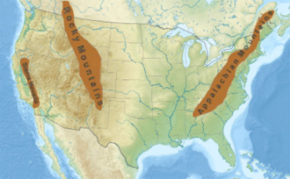
Mountain Ranges
The three major mountain ranges of the US are the Appalachian Mountains, the Rocky Mountains, and the Sierra Nevada.
the Mountain Ranges alphabetically, by name:
| Mountain Range | Location | Length |
|---|---|---|
| Rocky | The Rocky Mountains, commonly known as the Rockies, are a major mountain range in western United States. The Rocky Mountains stretch more than 3,000 miles from Canada to New Mexico, in the Southwestern United States. | 1st |
| Appalachian | The Appalachian Mountains often called the Appalachians, are a system of mountains in eastern United States. The Appalachians run for 1,500 miles along the east coast of the United States from northern Alabama to Maine. | 2nd |
| Sierra Nevada | The Sierra Nevada is a mountain range in the Western United States where the majority of the range lies in the state of California with some in Nevada. The Sierra runs 400 miles north-to-south, and is approximately 70 miles across east-to-west. | 3rd |
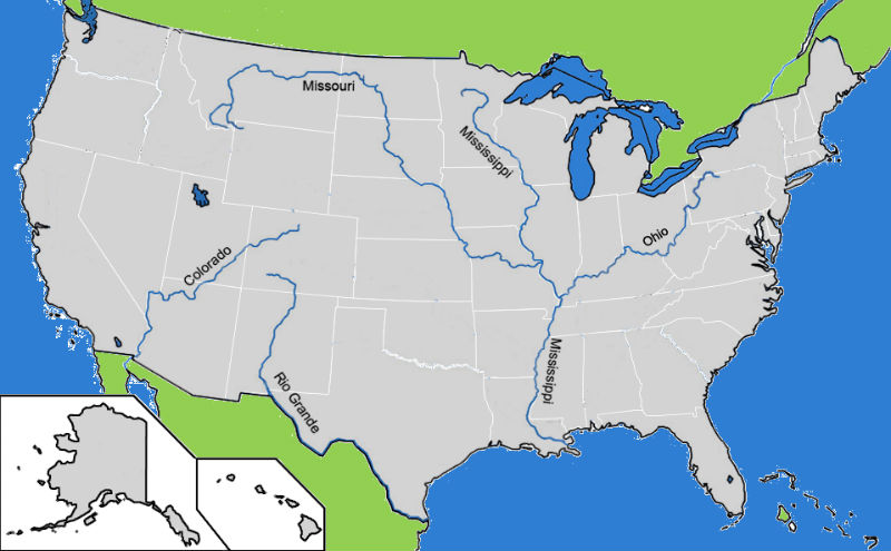
Rivers
Five important rivers of the US are the
- Mississippi
- Missouri
- Colorado
- Rio Grande
- Ohio.
the Rivers alphabetically, by name:
| River | Location | Length |
|---|---|---|
| Missouri | The Missouri River is the longest river in North America. The Missouri source is Montana and it generally flows southeast for 2,341 miles before entering the Mississippi River. When combined with the lower Mississippi River, it forms the world's fourth longest river system. | 2,341 mi |
| Mississippi | The Mississippi River is the chief river of the second-largest drainage system on the North American continent. The stream is entirely within the United States its source starts in Minnesota and it flows generally south for 2,320 miles to the Mississippi River Delta in the Gulf of Mexico. | 2,202 mi |
| Rio Grande | The Rio Grande is one of the principal rivers in the southwest United States and northern Mexico. The Rio Grande begins in Colorado and flows to the Gulf of Mexico. Along the way, it forms part of the Mexico–United States border. | 1,759 mi |
| Colorado | The Colorado River is one of the principal rivers of the Southwestern United States and northern Mexico. Starting in the Colorado Rocky Mountains in the U.S., the river flows generally southwest towards the international border. After entering Mexico, the Colorado approaches the tip of the Gulf of California between Baja California and Sonora. | 1.450 mi |
| Ohio | The Ohio River, which starts in Pennsylvania flows westward to Illinois, is the largest tributary, of the Mississippi River. The 981-mile river flows through or along the border of six states before draining into the Mississippi.. | 970 mi |
SST-04.5.02
 SST-04.5.02 Identify the political regions of the United States (e.g., Midwest, Northeast) and their relative locations
content
SST-04.5.03
 SST-04.5.03 Identify the location and characteristics of significant features of North Dakota (e.g., landforms, river systems, climate, regions, major cities)
content
SST-04.5.04
 SST-04.5.04 Explain how the physical environment (e.g., rainfall, climate, natural hazards) affects human activity in North Dakota
content
SST-04.5.05
 SST-04.5.05 Identify different patterns of land use in North Dakota (e.g., land use in urban, suburban, and rural areas, mining, agriculture, manufacturing)
content
SST-04.5.06
 SST-04.5.06 Describe ways geography has affected the development (e.g., the development of transportation, communication, industry, and land use) of the state over time
content


